My best guess was around 250'. So taking a few minutes to think about all that happened in a short, what seemed like an accelerated time frame, my best guess is that I was closer to 400 than 700 feet when the crap hit the fan. I had no way to prove my new theory.
You're wondering why the heck does it matter now...because it does to me and the pilot decisions I made that day. This is why I am so desperate to see the video, I need that closure.
The New Findings...
What really confuses me is that I went through my iPhone and Foreflight to look for a possible recording of the flight track and could not find anything labeled for the KOXB-KPSK leg. I'm not sure what possessed me last night but I was going through Foreflight and working with flight planning. When I finished I thought I would clean out any old flight track logs that had been stored. I went through each one and clicked on a KOXB-KOXB file and was floored. There it was, our brief flight from June 29th.
I exported the .kml file in hopes of gaining more info through Google maps. The actual flight time on Foreflight listed 1:12. I opened Google and loaded the .kml file. I was stuck in stupid, frozen, there before my eyes was a flight plan with the altitude ladder bar staring me in the face. How the heck can I measure this, how do I get Google to show me altitudes or elevations?
I immediately went to the tool option and noticed GPS and Ruler. I clicked on GPS but I needed the Garmin VIRB and that's still with NTSB. So, my second option was Ruler. I used the option and picked out two points on the vertical ladder bar that measured 518.89 feet. What! I had thought I was at maybe 700 feet when asked by first responders the day of the accident. The quick path option showed 518' Wow! I was speechless. I had to dig deeper.
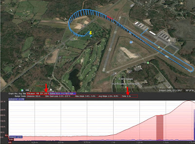
I needed something more solid than picking two random points on a line. I searched online for google map information and found that I can use the Show Elevation profile listed under the Edit link. And so I did, carefully following the online instructions to allow the file to plot the info I was so desperate to see.
Here is the plot of the highest elevation I reached that day, 331 feet. From wheels up to the point of impact 51 seconds. The plot also showed where the first vibration hit just after wheels up during my smooth climb out.
From the initial vibration to the secondary strong vibration and power loss was three seconds. You can see, from that point I did my best for maintaining the best rate of climb. Avoiding a stall, I made the left turn for my plan B, the golf course.
I'm still not sure how or why we both survived, but flying the plane was priority one and watching my airspeed to avoid a deadly stall spin was my constant focus. I'm still looking forward to watching the video to confirm what I have found and plotted.
Thanks for following along on this journey. It's not the travel postings I love to write about, but, it's a personal journey for me to find closure as a pilot and a survivor.


4 comments:
It's gripping reading, Gary. I can't read this without putting myself in your place. However it went down, you must have done the right thing, because you're both still here with us.
Chris,
Keeping with my sense of humor....."even a blind squirrel finds a nut now and then" I'm not sure of the exact process other than FLY THE PLANE. Thanks for reading along as I work through the process to get back in the air.
It helps when that blind squirrel is well-trained and proficient, Gary.
touché :)
Post a Comment