I am focusing on the GNS 480, utilizing the simulator, and 'what if' scenarios that I think up, or the flying forums provide. This morning I found just such a scenario on one of the forums. Insert evil mad scientist laugh.
OK, here we go, taken from one of the flying forums I frequent.
 |
| http://clipart-library.com/pictures-of-a-scientist.html |
OK, here we go, taken from one of the flying forums I frequent.
Assume I want part of my eastbound route at 11000
to be: CNX V264 V62 TXO. First is this technically allowed since there is not a
named intersection where the airways cross? And assuming it's ok then how would
you get that into any navigator? I can't figure out a way to get it into
Foreflight or the GNS480.
The best workaround I can come up with is making the route something like CNX V264 TCC V12 ACH V62 TXO, and then when I reach the point where V264 and V62 cross I could just activate the leg from ACH->FLUTY (I could identify the crossing using the VORs).
Lets take the easy route first, ForeFlight. Similar to my previous Intersecting Points post, this is a simple entry. If you have the ability to upload Foreflight with the FlightStream products, you're one and done.

CNX CNX051/TXO278 TXO
This will plot the intersection at V264 and V62, you're good to go.
Now on to the GNS 480.
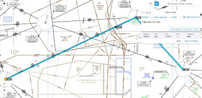
The original flight plan would be CNX V264 TCC TXO. I assume the original plan was to avoid the Pecos High/Low MOA area. The above plan does that but unless you ask or are given the short cut along V62 you're flying way out of your way to get to TXO. Lets fix that, and save some fuel.
 I selected the following flight plan by clicking on the FN soft key then the FPL soft key. I then entered CNX V264 TCC TXO. Notice there is a discontinuity after TCC, the unit is looking for a way to get there.

 After selecting EXEC the MAP page shows the route. Note the route CNX -> TCC -> Disco. Now we need to add the CrsTo, in order to plot the route to TXO.
 I selected the following soft keys. FN, FPL, EDIT, CRSR to highlight discontinuity which highlights TXO. Next click on the direct soft key.
 Your screen now provides multiple choices select MORE in the box. Next you will select CrsTo and with the CRSR dial in 98*.
 Click on the soft key button MENU/ENTER. You should now be back on the map page, you are still on a 053* heading on V264 and you can see the 098* radial.
 Select the soft key FN, FPL and EXEC then MENU/ENTER.

 Select the soft key MAP and you will see the 098* radial (V62) highlighted. You will now fly on the 053* heading and intercept the 098* radial TO TXO.
 Next up, how to create a user waypoint that will provide the same point in space. This user waypoint comes in handy if ATC sends you to that same point in space on your flights.
The best workaround I can come up with is making the route something like CNX V264 TCC V12 ACH V62 TXO, and then when I reach the point where V264 and V62 cross I could just activate the leg from ACH->FLUTY (I could identify the crossing using the VORs).
Lets take the easy route first, ForeFlight. Similar to my previous Intersecting Points post, this is a simple entry. If you have the ability to upload Foreflight with the FlightStream products, you're one and done.

First, click on the FPL selection, top left. Next, enter the flight plan. The V264 is not required but I forgot to delete it.CNX CNX051/TXO278 TXO
This will plot the intersection at V264 and V62, you're good to go.
Now on to the GNS 480.

The original flight plan would be CNX V264 TCC TXO. I assume the original plan was to avoid the Pecos High/Low MOA area. The above plan does that but unless you ask or are given the short cut along V62 you're flying way out of your way to get to TXO. Lets fix that, and save some fuel.


No comments:
Post a Comment