I started out with my planning last night (actually about the 4th trip I went through the process for practice) for my first dual XC. The trip was N99 to THV then off to LNS and a final route back to the home field. A final call to wx-brief at 6:30 had the forcasted winds changed from 23522 to 2414 for my planned altitude of 4500. I sat down and refigured my course corrections, leg times and fuel prior to leaving the flight school office.
I had my small clipboard ready with all the things I thought I would need. Sharpened pencil with backup's, a print out from the AOPA airports information with the taxi diagram copied on the flip side for THV and LNS. The print out made for quick references if needed and gave me an idea where I would be going on the ground. After completing all the checklists and entering all the comm info and nav info we were off. I started the timer on my takeoff roll, make that a short field take off roll, MY CFI threw that in there for the practice. My head was busy enough trying to think way ahead for my course besides the newbie’s slightly overwhelmed feeling.
Climbing out it was smooth as glass, what a relief! I reach altitude on schedule and at my first checkpoint at the correct time, so far so good. I already have the MXE outbound 280 radial dialed in to maintain my heading which corresponds to my flight plan heading. I'm feeling pretty good. Now comes my next leg of 23 miles or so with only towns along the way. A town comes by on my right and I am noticing my VOR is tracking all over the dang place.......something seems not quite right. I am flying on the south side of Quarryville instead of the north side. My CFI now chimes in, Lesson #1 PILOTAGE always pilotage with electronics as a backup, he then reaches up and hits the nav/gps button....ARRGggggghhhhh :( Ok, no time to putz here its water under the bridge as they say and I need to now find my location. Well I know I am south of my planned course so I look to my next point since I have visual on it (Susquehanna River)and begin to look for check points. My CFI asks what I am looking for and how do you correct your course. I am looking for the Dam as my crossing point with the LRP VOR 208 radial as a secondary confirmation, I have neither. I do however have the power station off my left wing and proceed with a right turn up river to the Dam. By the way I hit the river time mark a tad late. I am now heading to the dam which at that point I will turn left to a heading 280* and that should leave me about 5 minutes out. Lesson #2 when you think you’re "lost" but that’s not the term he used remember the three C's - Circle, Climb and Communicate, followed by a detailed explanation of all three. Lesson well learned.
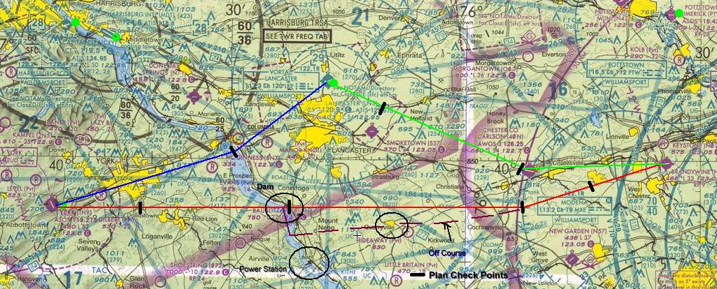
My next point is RT83 running north/south, main highway can't miss it. This will come just after I pass between two towns; the larger is York to my right and just off the left wing Red lion/Dallstown. I pass a distinctive body of water under the left wing so I'm looking good and I see the hills just off of runway 35 as a fellow AOPA board member pointed out (thanks for that heads up FlyersFan31). I announce my position and that I am crossing the field east to west at 2500. I thought I was ok to turn back as I worked to enter the left downwind on a 45* but I ended up fixating on the field and pinched way to close (Strike 1). I hurry along with my landing, as if that will make it better, (Strike 2). I then turn base with a very short final which of course has me (All white lights) high (strike 3). I announce going around, slightly frustrated, reminded for full power and communicate later eventually getting back to pattern ALT to give it another go. Bill tells me to relax I am doing fine, settle in and do what you need to do. Calling out cross wind and downwind I flow through my checklists and make ready for my landing. Ok, the picture looks much better, good spacing, speed and ALT good. Turning base then final I am a bit high so power off last notch of flaps and a real nice landing. Wow that felt great! I taxi off and get set up for my take off to LNS. We let this Gorgeous Fairchild taxi on by who is ready to go......this baby looked sweet!
I set up my comm and Nav for LNS and depart York for the quick hop. I climb out to 3000 staying clear of the TRSA as I recross the Susquehanna noting the double bridge checkpoints on my left. I call LNS tower to report the who, what, where and with ATIS report "E"cho. I report 4 mile final for runway 8 followeed shortly by a cleared to land as instructed. Well that was a short and sweet hop, now it's time to head home.
The return trip was smooth as could be, taking up a 120 degree heading for MXE VOR and crossing over Chester County (40N) I decide to cut short my course to MXE and instead turn east for home. I get a visual on Brandywine and swing out to enter on a 45* for downwind 27. Following my initial call to brandywine traffic Bill jumps in and tells me to correct my position; I'm about 3-4 miles not 8 miles out. He then talked about Modena and the distance from there which I said is 6 miles on the 54* radial to the airport.....Hmmmmmm and yes Modena (MXE) is behind me. Lesson #3 Bill reminds me to ALWAYS announce position correctly and the importance of letting others know where we are, the airport is the most busy place, make sure I always advise traffic and keep the head on a swivel.
Well that’s it, long winded but I needed to vent just to release some of the adrenalin rush. I am up for my next dual to Hazelton - Allentown next week depending on weather. It just keeps getting better!
No comments:
Post a Comment