Saturday July 28, 2012
Mary wasn't feeling well this past week so we canceled our typical beach run and instead made it an overnight. I filed for OXB trying a new route that would allow me to maintain above 4000, Dover always drops us down when we go inland on V29.
 |
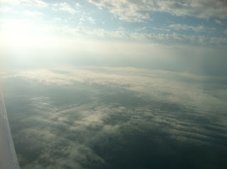
| Some clouds but not a bad flight south |
 |
| Looking across the bay at the layer over south Jersey |
The route was simple and efficient, ILG ATR Direct, sadly, it was a no go. I copied as directed radar vectors to join V29 SBY KOXB, but I did get 6000. The difference in altitude directly relates to the difference in temperature and makes the flight comfortable on us and our Maggie girl. The weekend was enjoyable all be it to short.
 |
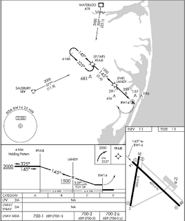
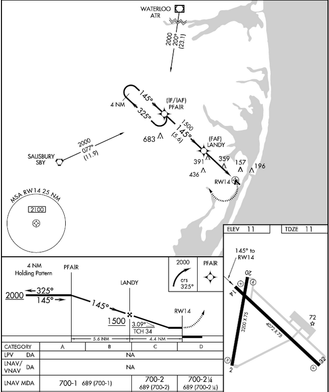
| turning direct to the hold at PFAIR |
 |
| The hold (racetrack) |
 |
| Descending out of the hold and in the clear for a short while |
I didn't hear any traffic into or out of KOXb but Patuxent decided to put me in a hold, as pictured above. Not a big deal and the practice will do me good. I was directed to hold as published, NW at 4000, expect one lap. I proceeded direct to PFAIR and reported entering the hold at PFAIR reporting altitude but forgetting the time. Approach responded expect further clearance at 1223 Z time now 1220Z. I acknowledged and continued on my four mile outbound leg. Once inbound and crossing the fix I was cleared to descend to 1700, 200 above the plate altitude at my next fix but not a big deal. I entered the next layer around 1200 and broke out just under 850, 150' above minimum descent altitude. It's always a blast to see the runway right where it should be!
It was a lazy Saturday but we did manage to make it out for dinner. We tried a new place, OC Steamers. It was great food and good service despite the crowds. We plan on making this stop again soon. As we left the restaurant and started across the RT 90 Bridge west back to the Motor Home I snapped this picture, over the Assawoman Bay.
Sunday July 29, 2012
It's departure day and the terminal area forecasts look great! We decided to stay and cookout, enjoying dinner off the grill. I had just said to my Bride I guess we'll head to the airport and head out around 4:30 when we heard a loud rumble of thunder. I grabbed my iPhone to check wx and went outside for a visual. Both the phone and visual confirmed, it was getting dark and lightning was just off to our north.
 |
| This storm cell popped up over our Motor home location on departure day |
We sat out the downpour and light show as the red eyed blob on the iPhone shows, then decided to head out for the airport early. There was a large cell moving across the Cape May Atlantic City NJ area as well and I was watching to make sure it didn't decide to cross the bay and head down the coast.
 |
| The view to the NE, the building clouds are pictures on the GPS shot above around 15-18 degrees |
 |
| Cape Henlopen state park at our 3 o'clock |
Upon arrival Saturday morning I had decided that 25 gallons was good to get us home on Sunday leaving us a 15 gallon reserve. After watching the wx come up so quickly this afternoon I taxied over to self serve and added to my safety factor bringing my total to 40 gallons or 4 hours for my one hour trip home. I rather have extra fuel for deviations around buildups if necessary and fuel to fly to an alternate place to land.
I had filed for the flight home but decided to make the flight VFR, having the IFR flight plan handy if I needed a pop up into our destination. We launched into very good VFR conditions and quickly identified the new cells we were seeing miles off in the distance moving into KGED, Georgetown, just west of our route. This was a slow mover so I worked my way to the coast of the Delaware Bay around Lewes DE., and followed the Delaware shore line home.
 |
| The visual to match the GPS shot above |
It was smooth flying until Dover, I had passed the storm cells to our west and the cells over NJ were at a very safe distance heading more south east then my direction west south west. I did have one layer of clouds that spanned the bay at the mouth of the Delaware river. I was at 3,500 and requested 2000 from Dover to maintain VFR. It was granted and down we went.
A gradual descent that was timed right. As we got closer I started to descend to 1500 to give myself clearance, I was maybe a half mile off shore. Fly the plane first so I started down as as soon as I broke 1900 Dover asked to advise Altitude. I responded out of 2000 descending to 1500 for a layer will get back to 2000 as soon as I clear, Dover acknowledged.
We dipped under the layer and then climbed right back to 2000 to continue the last 14 minutes or so into Wilmington. Dover called out two targets heading west at our one and three o'clock, five hundred high, we never saw them and if they were at that altitude they were in the cloud base flying VFR, bad mojo.
Dover turned us loose and we contacted Wilmington tower as we crossed the C&D canal, our ten mile marker from the south. I was cleared straight in runway one, report four mile final, I acknowledged. I set up for the ILS RWY one on the Garmin 530 and reported four miles as directed. I made a nice landing, a bit long on purpose, in order to speed up my exit to the taxiway for the twin holding short for my arrival.
Mary and I went through the routine and had 08R secured in short order. We made one stop for dinner to go at Bertucci's and headed home.


2 comments:
Good ADM and great call on the extra fuel. That whole "fuel not in your tanks" pilot axiom and all... never a bad idea!
Yep, to much wx going on, better to be safe.
Post a Comment